Tag:tourism=wilderness_hut
| Description |
|---|
| A remote building, typically unserviced, providing temporary shelter and sleeping accommodation. |
| Rendering in OSM Carto |
| Group: tourism |
| Used on these elements |
| Useful combination |
| See also |
| Status: approved |
| Tools for this tag |
|
![]() Wilderness hut, backcountry hut or
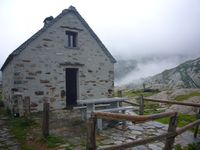
Wilderness hut, backcountry hut or ![]() bothy is an unserviced remote building, with generally a fireplace or heating stove, intended to provide temporary shelter and sleeping accommodation (unserviced, no staff present).
bothy is an unserviced remote building, with generally a fireplace or heating stove, intended to provide temporary shelter and sleeping accommodation (unserviced, no staff present).
Required properties:
- Remote building found in the countryside
- The access is usually restricted to foot, mountain bike or ski.
- Open to the public, usually for free, but may require an overnight fee in some countries (for private accommodations use tourism=chalet instead)
- No permanent human presence, no staff. For staffed facilities use tourism=alpine_hut.
- Equipped with beds or suitable sleeping areas
- Fireplace or stove for heating and cooking (if there is no fireplace, consider using amenity=shelter + shelter type=basic hut instead)
- Fully enclosed (with roof and walls)
Wilderness huts are typically made of stone or wood. Keys may be needed to enter. Owner's vehicle access through restricted tracks might still be possible, also access by cable lift or helicopter.
How to map
Place a node at the hut location or draw an area along its outline. Add tourism=wilderness_hut.
Note that tourism=wilderness_hut alone does not automatically cause the building to be rendered. Consider adding an appropriate building=* tag, such as cabin, hut, bungalow or, at minimum, yes.
| Key | Value | Discussion |
|---|---|---|
| shower | yes/no/hot/cold | Showers are available inside. If separate from the hut, please add amenity=shower as a separate point. |
| mattress | yes/no | If mattresses are available |
| drinking_water | yes/no | If water is available inside (or aside). |
| toilets | yes/no | If toilets are available inside. If separate from the hut, please add amenity=toilets as a separate point. |
| reservation | yes no required recommended members_only |
yes - reservation is possible no - there is no reservation option for this amenity required - you have to reserve if you want to sleep at the hut recommended - you should make a reservation members_only - reservation is only possible for members of the organisation running the hut |
| access | yes/private | the hut is locked and can be used only with permission of the owner |
| locked | yes/no | the hut is locked and can be only used after retrieving the key. If possible, write how to obtain the key in description=*. |
Other useful generic tags :
- ele=* elevation
- name=* name
- capacity=* sleeping capacity
- fee=yes require overnight fee
- fireplace=yes if there is a fireplace to heat the hut
- description=* fill more information with text
- access=* useful values are access=yes and access=private. NOTE. This tag should not be confused with the status of the operator (e.g., DAV/CAF/SAC owned vs. privately owned. Private would indicate that the hut is only open to members or associates of the owning organisation (this is the typical status for mountain huts in the UK, see discussion).
- operator=* typically used to indicate huts owned or maintained by a specific organisation. E.g. Mountain Bothies Association, Österreichischer Alpenverein, administration of forest or national parks.
Examples
Rendering
See Proposed features/wilderness mountain buildings#Rendering
See also
- tourism=alpine_hut - A remote building located in the mountains intended to provide board and lodging.
- amenity=shelter + shelter_type=basic_hut - A basic hut is a small building intended to provide basic shelter and sleeping accommodation.
- amenity=shelter + shelter_type=lean_to - A lean-to is a shed with typically three walls located in the countryside intended for camping.
- Complete proposal Proposed_features/Wilderness_hut
- building=barn
- building=cabin
- building=hut
- building=shed
- amenity=shelter


